
Driving California’s Pacific Coast Highway
Ask people to name the most iconic USA Roadtrip and you can bet California’s Pacific Coast Highway will be in the top 5. Most travellers will tell you that the road runs from Los Angeles, up the West coast to San Francisco. Actually, the ‘official’ PCH is only 130 miles long and runs from Dana Point in Orange County to Oxnard. It could ,however, be argued that the actual road qualifying as the Pacific Coast Highway should be that which stretches from the Mexican Border near San Diego, right up to Canada.
It’s the California stretch which attracts most travellers though, and specifically the 380 mile stretch between LA and San Francisco. (or 460 miles if you take the route which hugs the coast). The drive takes about 6 hours in total (9 hours for the coastal route) so could be covered in one day, though most visitors spread it over at least a week. A popular circuit takes in the PCH between LA and San Francisco, onto Yosemite NP, down past Death Valley to Las Vegas, then back to LA. That’s easily achievable in a couple of weeks so lends itself well to a 2 week fly drive holiday.
The road is officially called Highway 1 or State Route 1, though at times it runs concurrently with the US 101 highway which takes an inland route at certain points, whereas Highway 1 stays closer to the coast. Many travellers will start their journey by collecting a rental car at LA International airport (LAX). Luckily the airport is in the North West of the sprawling metropolis so it’s easily placed to pick up the road at Santa Monica. LAX to Santa Monica takes about 20 minutes (longer at rush hour) via the Santa Monica Freeway (Interstate 10) or Lincoln Boulevard which runs South of the airport.
Alternatively, you could stay in Santa Monica for your first night and rent a car there from a local company.If you want to go for a one way rental and drop the car in San Francisco you may be better looking at Hertz or Enterprise who both have branches in Santa Monica. All the big brands have outlets at LAX.
Santa Monica is a pleasant enough seaside area to stay, and is a good base for visiting the LA area. The Pacific Coast Highway running through the town is known as Palisades Beach Road. It then begins its run North through Pacific Palisades and onto Malibu where it runs along the coast for the full 21 miles of Malibu’s City boundaries, and allows you to see some of the fantastic beach front properties that area is famous for. At Oxnard, the US-1 merges with the US-101 for the first time.
The combined road enters Ventura County, and you pass the Mugu Rock, a formation left when the road was cut through the surrounding cliffs. It’s a popular but dangerous place for fishing, sightseeing, cliff diving, and rock climbing up the sheer sides of the rock itself. The town of Ventura is to the North and is a pleasant town , situated around 65 miles from Santa Monica, and should take around an hour to drive. If you aren’t intending to spend time in LA , I find that Ventura can be a pleasant place to stay for a day or so to acclimatise after your flight.
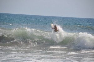
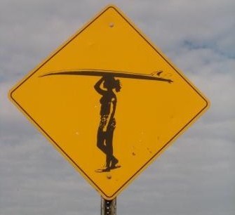
The next main town on the road is Santa Barbara around 30 miles away. This section is a nice scenic drive with the ocean ,mountains and on a clear day, the channel Islands visible offshore. Just South of Santa Barbara is Rincon Beach, a favourite surfing spot and a nice place to stop for a while and watch the action . Santa Barbara itself is a small, affluent City of around 90,000 people. It’s an attractive place with the Santa Ynez mountains rising behind the City and the glittering ocean to the front. Indeed, this stretch of coast is often referred to as the “American Riviera” because of its geography and similar climate to that of the French and Italian Rivieras.Santa Barbara has a lot of bars and restaurants and enough attractions to keep you occupied for at least a day and is a recommended stopping point on your drive North. If you don’t want to stop and just want a glimpse of the City, exit 101 at Cabrillo Blvd., follow it along the waterfront to State Street. Turn right on State Street to Carrillo, then left on Carrillo to rejoin US 101. (NB-thats not a mistake- Cabrillo and Carillo are separate streets)


The coastal highway continues to hug the coast West of Santa Barbara, until it veers away from the ocean and over the Gaviota Pass. There’s a rest stop here and camping is possible at nearby Gaviota State Park which is popular for picnicking, swimming, angling and hiking. US-1 and US-101 split here – most tourists follow 101 inland and towards the Danish town of Solvang which is just off US 101 (you can also reach it via Highway 154 which runs North out of Santa Barbara, and allows you to visit the Cachuma Recreation area en route). Solvang is shamelessly touristy with some Danish bakeries and restaurants and an ostrich farm but it’s an Okay option for a lunch stop.
If you stick with Highway 1 you’ll no longer be on a beachfront route as the road heads inland towards the small City of Lompoc and Vanderberg airforce base. Lompoc isn’t really a tourist town but bills itself as the Flowerseed capital of the world. It is also home to a bar, Jaspers, which Playboy magazine named as one of the top 10 ‘dive bars’ in the USA in 2010.
Highways 1 and 101 then meet again just South of Pismo Beach. Pismo Beach is a nice little beach town and is worth a visit. Nearby Oceano Dunes is also the only place in California where you can legally drive your car on the beach! There are a number of campsites in the area so Pismo Beach is a popular stop for RVs on the coastal highway .If you just want to make a quick visit, exit US Hwy 101 at Beach Drive and park downtown.
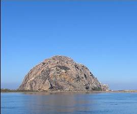
Highway 101 heads inland at this point and splits again from Highway 1 at the historic town of San Luis Obispo, with its 18th century Spanish Mission. As we’re trying to stick with the coastal route as much as possible, we now follow US-1 out of San Luis Obispo around 10 miles to Morro Bay. You can’t miss the town’s most famous feature, the huge Morro Rock in the sea in front of the town which is one of seven worn-down ancient volcanoes that extend in a line to San Luis Obispo. Morro Bay is a popular site for bird watchers with hundreds of species who winter in the bay.
The road then heads along the coast through the small communities of Cayucos and Harmony and on to Cambria. Cambria is a great stopping off option with art and craft galleries,bars and restaurants and Moonstone beach complete with crashing breakers and surfers. The town is exactly halfway between Los Angeles and San Francisco. It’s 290 miles from Sacramento, 125 miles from Monterey and 425 miles from Las Vegas. Cambria is also a good base to visit one of the main attractions on the PCH, Hearst Castle,one time home of industrialist and publisher William Randolph Hearst. Situated just above the small town of San Simeon, the Moorish style castle has 165 rooms and is set in 127 acres of gardens, terraces, pools and walkways, furnished with Spanish and Italian antiques and art, flanked by three large guest houses. In its heyday, Hearst Castle had a zoo, tennis courts and two huge swimming pools, including a huge Roman themed one. It’s now classed as a state park and is open to tourists and is seen as one of the major attractions on the Pacific Coast Highway. It’s advisable to book at busy times. If natural attractions are more your thing, and you visit between December and February, you may prefer to drive 7 miles past San Simeon to visit the large elephant seal colony at Piedras Blancas. (Be warned- it doesn’t smell too good!)


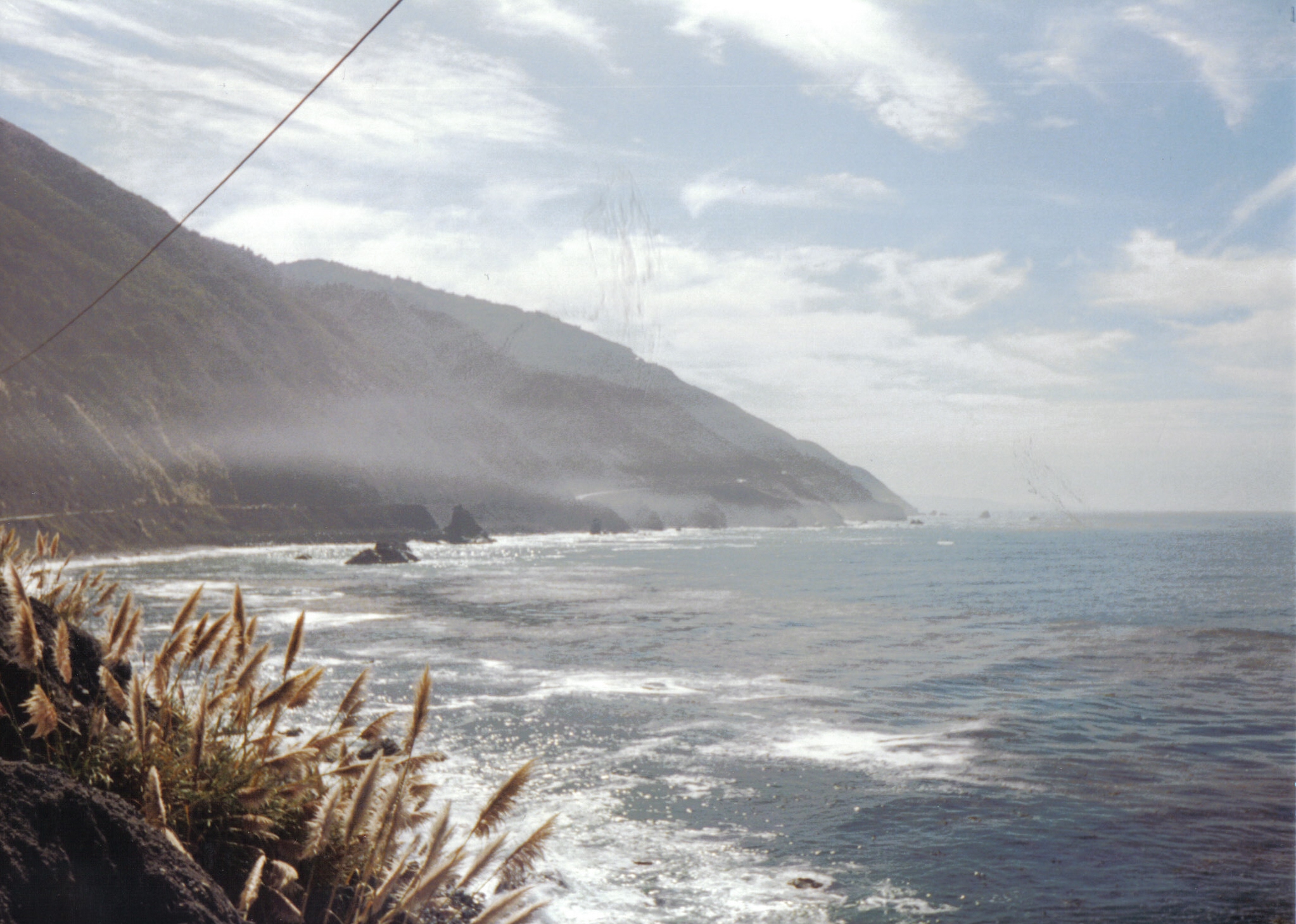
The next 65 miles between Piedras Blancas and Big Sur is probably one of the most scenic and iconic sections of the road. It should take between 1 hr 30 minutes and 2 hours to drive but it’s likely you’ll want to stop for photos, so you should allow yourself longer. A word of warning –US-1 often closes in the Big Sur area after rain which causes landslides. (Although I experienced a closure and it hadn’t rained for weeks!).
The condition of the road can be checked on the CalTrans website- http://www.dot.ca.gov/cgi-bin/roads.cgi . In the road checker, Enter 1 (the highway number) and search. You can get the same information on web enabled mobile devices – or by phone at 800-427-7623. Small mudslides will close the road for minutes or hours but after heavy rain in winter the road can be damaged to such an extent that it’s out of action for weeks.
If Highway One is closed you’ll have to take a detour. There are few roads crossing the coastal mountains, so US Hwy 101 is your best bet to get around the closure. To reach 101 you’ll need to take Highway 68 between Monterey and Salinas in the north and Highway 46 between Cambria and Paso Robles in the South. If the coast is only closed at one point its worth checking out how far you can actually drive along the coast –you may still experience a great scenic drive even if you have to turn around and head back the way you came!
There are a number of places you’re likely to want to stop at on the Big Sur coast such as – Jade Beach, between Gorda and Plaskett Creek, which as its name suggests is a beach where you can sometimes find pieces of jade; Julia Pfeiffer Burns State Park which has a waterfall cascading to the beach; Willow Creek which is an excellent viewpoint and Pfeiffer Beach with its purpleish coloured sand. You may also be lucky enough to spot a huge condor gliding on the thermals between Julia Pfeiffer Burns State Park and Big Sur Town. Theres also a hotel at Ragged Point if you decide to stay in the area and numerous accommodation options in Big Sur town.
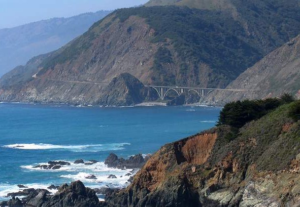
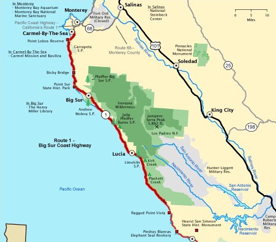
North of Big Sur, the road runs inland through a wooded area before emerging by the sea and running as a coastal road again. There are some excellent viewpoints on this stretch and you’ll pass Point Sur lighthouse and the Bixby Bridge as you head towards the Monterey peninsula home to the small towns of Monterey, Pacific Grove, Carmel Valley and Carmel-by-the-Sea, one of which you’ll no doubt decide to spend a night at. The famous 17 mile drive road runs between Pacific Grove and Carmel. It’s a toll road running through a private community and takes you on a scenic route past a number of top golf courses, Pebble Beach and the famous Lone Cypress tree. It’s a pleasant enough excursion but if you don’t want to pay there are plenty of other scenic drives in the area such as Ocean View Blvd. from the Monterey Bay Aquarium to Asilomar State Beach.
Monterey Bay has more of a ‘town’ feel with attractions such as Monterey Bay Aquarium and souvenir shops at Cannery Row, an old Sardine factory and famous Jazz and Blues festivals. There’s also the chance to spot Sea Otters in the harbour. Carmel is more of a touristy village which won’t be everyone’s cup of tea –it used to get a lot of visitors when Clint Eastwood was mayor! I once had a spooky night in a B+B here too when I was kept awake by the resident Poltergeist…
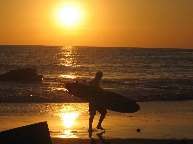
After leaving the Peninsula you rejoin US1 and head round the bay towards the surf town of Santa Cruz which has a lively, college town feel and a traditional fun fair on the beach. It’s a good place to stop for a night before heading onto San Francisco.
US-1 then passes through largely agricultural land as it heads North and you’ll pass Ano Nuevo State Beach where it’s possible to see Northern elephant seals in January or February, if you missed them at Piedras Blancas back down the coast. There are also some nice beaches on the way up to the laidback seaside town of Half Moon Bay.


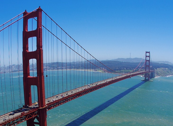
You then hit the town of Pacifica and you’re really now in the suburbs of San Francisco, so you probably need to pull over and plan your route to your hotel. Although San Francisco is a big City with many accommodation options, I strongly advise you to reserve a hotel before you arrive so you at least have a location to head to. I speak from experience having hit town on a busy weekend and driven around for 3 hours trying to find a room – very stressful!
If you’re ending your trip in San Francisco you may decide that you don’t need a car whilst you’re in the City. In that case, you could return it straight to the airport. To do this follow Highway 1 towards San Francisco from Pacifica, then take I-280 south towards San Jose. You’ll then merge into I-380 where you can pick up signs for US-101 and the airport.
A few other things to bear in mind- as mentioned earlier, the road gets closed due to mud slides at various times of the year. Its also prone to fog. Though you’ll want to take your time to admire the scenery, keep an eye in the rear view mirror. In California it’s actually the law (and in my opinion a sensible one) that says if you’re on a single land road and 5 or more vehicles are following you, you must pull over and let them pass.
Finally, the eternal question –is it best to drive North to South or vice versa? Fans of North to South point out that you’re on the sea-side of the road and as many rest stops are on the beach side it’s easier to pull off the road in this direction. However, local opinion seems to be that the best views are from a South to North direction. I’ve driven the road twice, both South to North hence have written this from that respect.
Whichever way you do it, I’m sure you’ll enjoy this classic road trip!
There are a number of websites specialising in driving the PCH such as the one below –
http://www.pacific-coast-highway-travel.com/
If you are a car rental company or tourism company operating in California who would like to feature on DriverAbroad.com please check details on our Partnering page .
Some Driving distances and times –
Santa Monica to Santa Barbara – 95 miles , 1 hr 30
Santa Barbara to San Luis Obispo – 110 miles ,2 hrs
San Luis Obispo to Cambria – 35 miles , 45 mins
Cambria to Big Sur -75 miles , 1 hr 30
Big Sur to Monterey – 30 miles -45 mins
Monterey to Santa Cruz – 45 miles, 1 hr
Santa Cruz to San Francisco – 75 miles 1 hr 30
Although I try and keep the information in the site updated as much as possible, in a rapidly moving world, situations can change daily. Therefore please use the site as an approximate guide, and in conjunction with other resources in order to form your view on driving conditions, roads, safety etc.
4 comments